|
Start/Finish
|
Skyline Ridge Open Space Preserve parking lot on the west side of Skyline Blvd. (Highway
35), 0.9M S/SE of the intersection of Page Mill Rd. and Skyline Blvd. (35), and 5.4M
N/NW of the intersection of Rt. 9 and 35. |
|
Driving
|
From the north/east, it is probably best to use 92 or 84 to reach 35 (Skyline), and
then go south until you pass Page Mill Rd. and then go 0.9M further on the right.
From the middle of the Peninsula (e.g., Palo Alto), Page Mill or Moody/Page Mill to Skyline, then left 0.9M. From the south, ascend to 35 on Rt. 9 from Saratoga, and then go north 5.4M to the
preserve on your left. |
|
Date
|
Saturday, Sept. 28, 2013 |
|
Start Time
|
9:00 a.m. [Sunrise 6:24 am; Sunset 8:02 pm]. Race briefing will start at 8:45 and
the race will go off promptly at 9. Please arrive with suitable time to spare.
EARLY START: If and only if you are expecting a finish in excess of 7 1/2 hours, there is an early start at 8:00 a.m. You will be timed, but you are not eligible for any awards (after all, you're running when it's cooler). We will attempt to have registration available at 7:30; definitely no earlier! There is a 5-minute walk to the start, though, so don't cut it too close. |
|
Distance
|
50K |
|
Fee
|
There is a mandatory registration fee for the race (because I can no longer afford to subsidize the race expenses myself). However the race is also, as it has been, a fundraiser for the environmental conservation work of the Santa Clara Valley Audubon Society. When you register you will find a mandatory minimum fee of $25, and different levels of optional additional amounts which will go straight to Audubon (as will anything left from the $25 after expenses).
All contributions of $50 or more to Audubon will be entered in a special drawing for a fabulous museum-mounted bird photo. |
|
Registration
|
REQUIRED, and likely to sell out (i.e., race day registration is highly unlikely to be available). |
|
Timing
|
Using PocketTimer Pro
for iPhone from Stevens Creek Software (naturally) |
|
Aid
|
At 10.9, 19.3, and 24.9M (two water bottles or equivalent suggested). Full aid is provided, including water, sports drink, Coke, GU, potato chips, cookies, M&Ms, etc. GU and sports drink courtesy of  |
|
Post-Race Food
|
Yes, including sub sandwiches and other goodies |
|
Volunteers
|
Most welcome and very much needed! (Please use registration form below as well) Information
about various volunteer jobs is found here. |
|
T-Shirt
|
There is always a special giveaway at this race. The registration form asks for your T-Shirt size "just in case" we decide on a T-shirt, although it hasn't been in quite a few years. |
|
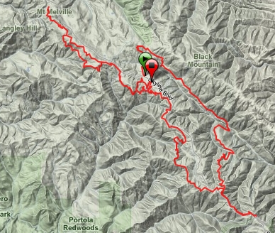
Route
|
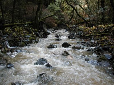
A mix of single-track and fireroad, covered woods and open hillsides. Two crossings
of Stevens Creek; quite likely in August neither will involve getting wet. Course drains well and only minor mud will be encountered, probably none unless it has rained hard and recently. The
basic route proceeds south (southeast) from the start via Stevens Canyon and up the
Table Mountain/Charcoal Flat Trail to Saratoga Gap, then back via Long Ridge Open
Space Preserve to the start, then north (northwest) along the Bay Area Ridge Trail
through Russian Ridge O.S.P. to Rapley Ranch Road and then back.
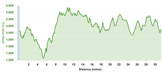
Climbing is approximately 5450' overall (see profile below) but with only one sustained climb (1100'
over 3.6M) and virtually all climbs are "runnable" (i.e., only a few short
"very steep" sections). At the same time, however, virtually the entire
course is rolling; there are no flat sections of any signficant length.
A detailed map and description
with distances is found here.
Watch a movie showing some of the views from the course
Some overall views of the course and the elevation profile:
A picture tour of the course can be found here.
Maps of all these trails are available online.
"Killer" - Sophia Lewis (or perhaps that was "a killer", not
sure ;-) )
"Deceivingly challenging" - Whit Rambach
"You should have seen the views yesterday" - Steve Patt |
|
Course Records
|
| Age Group |
|
Male |
Female |
0-29 |
|
Leor Pantilat, 25: 3:58:35 (2009) |
Julia Blanton, 27: 6:06:12 (2005) |
30-39 |
|
Jay Thomson, 31: 4:24:14 (2010) |
Sarah Slaymaker, 34: 5:03:38 (2005) |
40-49 |
|
Jean Pommier, 47: 4:15:40 (2011) |
Sophia Lewis, 40: 4:45:27 (2003) |
50-59 |
|
Joseph McDonald, 50: 5:01:32 (2004) |
Nancy Morehead, 50: 6:38:52 (2011) |
60-69 |
|
Roger Dellor, 61: 5:24:24 (2004) |
Christina Brownson, 60: 8:15:44 (2010) |
70+ |
|
Bill Dodson, 74: 6:49:25 (2009) |
|
|
Parking |
Plenty available at Start/Finish (free). When you enter the parking lot, turn LEFT and park in the "Equestrian lot" (i.e., do NOT turn right and park in the main lot which is where one usually parks at this preserve). |
|
Bathrooms
|
At the start there is a bathroom in the main parking lot (the one to the RIGHT when you enter), so when you arrive in the morning, you may want to go there first, then drive back to the other (lower) parking lot. On the course you pass (within 30 yards) that same bathroom just after the 19M aid/finish line at around mile 20; the only other bathroom is in the Skyline Ridge parking lot which you run through at mile 22 and 29. There are also 31 miles of trails. :-) |